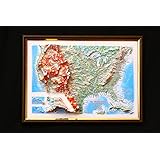
Hubbard Scientific United States Classic Raised Relief | A True 3D Map You Can Feel the Terrain | Vaccum-formed Molded Map | 36'' x 24'' | Detailed Topography
Maps International Giant World Map - Classic Large World Map Poster - Laminated - 46 (h) x 77.5 (w)
Raised Relief 3D Map of Israel (MEDIUM: 14.5 x 6.5)
MOVA Globe Relief Map Blue 4.5" with Base, Solar Powered Rotating Globe No Need of Battery or Chord, Unique Gift and Decoration
USA map - 2D Giclée Print - 3D effect shaded relief Poster of the United States - Vintage Style 1871 America Elevation Map (180gsm Matt, 24 x 18 in)
World Ranger 3D Map by Hubbard Scientific | A True Raised Relief Map - You Can Feel the Terrain | Vacuum-formed Molded Map | 36'' x 24'' | Detailed Topography
National Geographic: United States, The Physical Landscape 1996 - Historic Wall Map Series - 31.25 x 20.5 inches - Paper Rolled
Alps relief wall map Georelief: Reliefkarte
Laminated World Odyssey Map Poster | Executive Style Map | Includes The Most Legible Location Labels | 36" x 24" | Shipped Rolled in a Tube, Not Folded | Great for The Home or Classroom
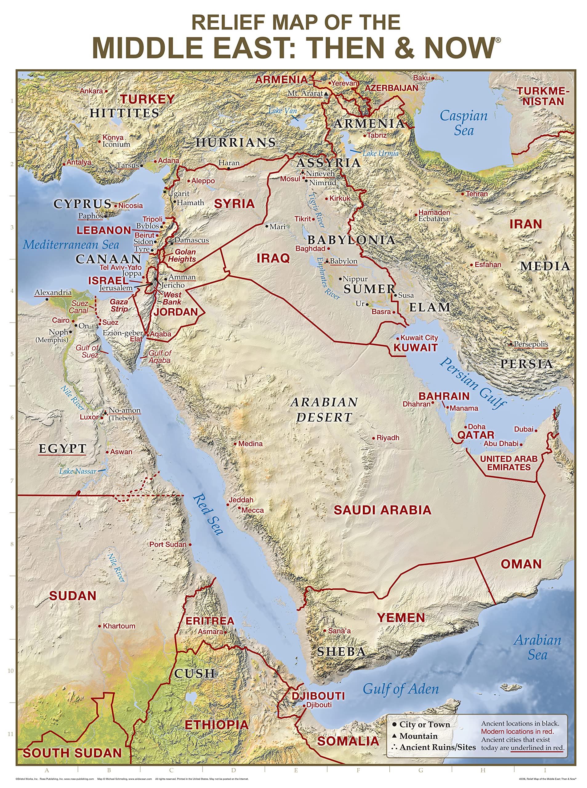
Middle East, Tubed: Wall Maps Countries & Regions
MOVAGlobe Relief Map Blue 6" with Base, Solar Powered Rotating Globe No Need of Battery or Chord, Unique Gift and Decoration
United States Classic Raised Relief | A True 3D Map by Hubbard Scientific - You Can Feel the Terrain | Vaccum-formed Molded Map | 36'' x 24'' | Detailed Topography
Hubbard Scientific 3D California Map | A True Raised Relief Map - You Can Feel the Terrain | Vacuum-formed Molded Map | 25" x 35" | Detailed Topography
GELS Vintage Relief Map Poster Wales Map Decorative Painting Canvas Art Picture 16x24inch(40x60cm)
Swiftmaps Africa Wall Map - GeoPolitical
Hubbard Scientific 3D United States Map | A True Raised Relief Map - You Can Feel the Terrain | Vacuum-formed Molded Map | 34.5″ x 22″ | Detailed Topography
Hubbard Scientific 3D Knoxville NI171 Map | A True Raised Relief Map - You Can Feel the Terrain | Vacuum-formed Molded Map | 32″ x 20.5″ | Detailed Topography
British Islands Geological Map - 3D effect relief Print (2D map with 3D effect using satellite terrain data) (200gsm SATIN, 32 x 24 IN)
Hubbard Scientific 3D San Francisco Bay SF2225 Map | A True Raised Relief Map - You Can Feel the Terrain | Vacuum-formed Molded Map | 22” x 25” | Detailed Topography
British Isles Map - bathy orographical - ocean depths and mountain heights Relief Map (200gsm Satin, 24 x 18 IN)
Reliefkarte Europa Gross 1 : 8 000 000: Tiefgezogenes Kunststoffrelief Map – 1 April 2011
Hubbard Scientific 3D United States Map | A True Raised Relief Map - You Can Feel the Terrain | Vacuum-formed Molded Map | 34.5″ x 22″ | Detailed Topography Map – Wall Map, 1 January 1993
Hubbard Scientific 3D North Carolina Map | A True Raised Relief Map - You Can Feel the Terrain | Vacuum-formed Molded Map | 38" x 19" | Detailed Topography
Raised Relief 3D Map of Israel (MEDIUM: 14.5 x 6.5) Unknown Binding – Wall Map, 1 January 2017
Hubbard Scientific 3D Great Smoky Mountains 403 Map | A True Raised Relief Map - You Can Feel the Terrain | Vacuum-formed Molded Map | 18.5″ x 12.5″ | Detailed Topography
3D Raised Relief Framed Map of USA - 12" x 9"
Hubbard Scientific 3D Texas 954 Map | A True Raised Relief Map - You Can Feel the Terrain | Vacuum-formed Molded Map | 28″ x 25″ | Detailed Topography
Hubbard Scientific 3D Vermont & New Hampshire 959 Map | A True Raised Relief Map - You Can Feel the Terrain | Vacuum-formed Molded Map | 22.75" x 32.25" | Detailed Topography
Relief Map Paperback – Import, 15 September 2017
Relief Map of the Middle East: Then and Now Wall Chart (Charts)
Relief Map of the Holy Land: Then and Now Wall Chart (Charts)
Hubbard Scientific 3D New Mexico NM1720 Map | A True Raised Relief Map - You Can Feel the Terrain | Vacuum-formed Molded Map | 17” x 20” | Detailed Topography
Historic Pictoric Wall Map, World - Ocean Floors and Land Relief. 1976 - Vintage Wall Art - 36in x 24in
Restoration Cartographic Washington State Restored Vintage Relief Map, Topographic Wall Art for the Home or Office, American States Series, 20 x 30 Inches
Construction of Maps in Relief. Illustrated
Muir Way - Tennessee 1977 Shaded Relief Map - Flat 2D Paper Print - Shaded 3D Illusion - Gallery Quality Fine Art Paper & Inks - 100% Cotton & Acid-Free - Made in USA - 40” x 12” 2D Print - No Frame
Hubbard Scientific 3D Alaska AK2421 Map | A True Raised Relief Map - You Can Feel the Terrain | Vacuum-formed Molded Map | 23” x 20.5” | Detailed Topography
The Relief of Kumasi. With 16 Illustrations and Plans and a Map
National Geographic World Ocean Floor - 42.5 x 29.5 inches - Paper Rolled
Muir Way - Idaho 1909 Shaded Relief Map - Flat 2D Paper Print - Shaded 3D Illusion - Gallery Quality Fine Art Paper & Inks - 100% Cotton & Acid-Free - Made in USA - 24” x 36” 2D Print - No Frame
Raised Relief 3D Map of Israel in Jesus' Time (Shows Place Names Under Roman Rule)
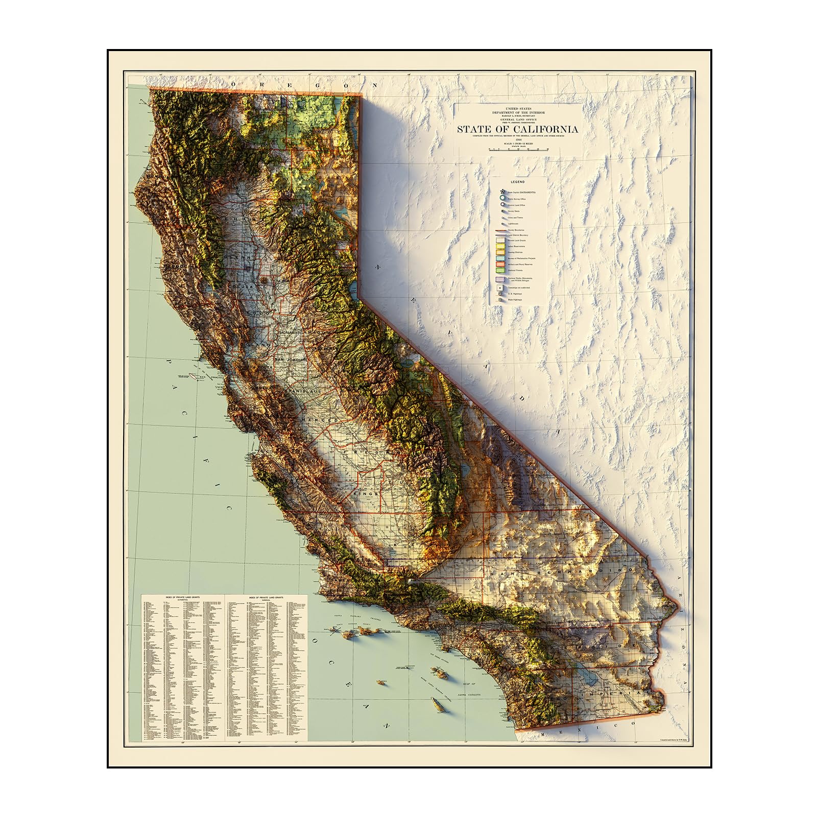
Muir Way - California 1944 Shaded Relief Map - Flat 2D Paper Print - Shaded 3D Illusion - Gallery Quality Fine Art Paper & Inks - 100% Cotton & Acid-Free - Made in USA - 42” x 49” 2D Print - No Frame
Relief Map of the Holy Land: Then and Now Wall Chart
Beibehang Exclusive BVZ0451 Golden Relief Qingming Shanghe Map Chinese Characteristic Culture Background Wall HD 3D Wallpaper(121 cm x 91 cm)
Muir Way - USA Geological 1932 Shaded Relief Map - Flat 2D Paper Print - Shaded 3D Illusion - Gallery Quality Fine Art Paper & Inks - 100% Cotton & Acid-Free - Made in USA -42” x 24”2D Print -No Frame
Hubbard Scientific 3D Yellowstone 419 Map | A True Raised Relief Map - You Can Feel the Terrain | Vacuum-formed Molded Map | 18.5″ x 25″ | Detailed Topography
Hubbard Scientific 3D Nevada NCR 2217 Satellite Map | A True Raised Relief Map - You Can Feel the Terrain | Vacuum-formed Molded Map | 22" x 17"| Detailed Topography
Holy Land New Testament Then and Now Relief Map (Charts)
Muir Way - Appalachian Trail 1981 Shaded Relief Map - Flat 2D Paper Print - Shaded 3D Illusion - Gallery Quality Fine Art Paper & Inks - 100% Cotton & Acid-Free - Made in USA - 24” x 36” - No Frame
OVANTO Scratch Off World Map & US Map-Durable 17x24” United States Map & World Travel Map with Pins & Accessory Set–Easy to Scratch Off Maps with Colored Details in Name-Tagged Gift Box for Travelers
72" W x 40" H - United States of America Wall Map - Extra Large - Features Shaded Relief Topography - Colorful, Decorative and Functional - Choose Paper or Laminated (both sides) (Laminated, 72" W x 40" H)
Hubbard Scientific 3D Cumberland NJ173 Map | A True Raised Relief Map - You Can Feel the Terrain | Vacuum-formed Molded Map | 31″ x 20.5″ | Detailed Topography
3D Raised Relief New York Framed Map - 12" x 9"
California Map 3D Raised Relief Framed Map Amazing Decorative Bird's-Eye View
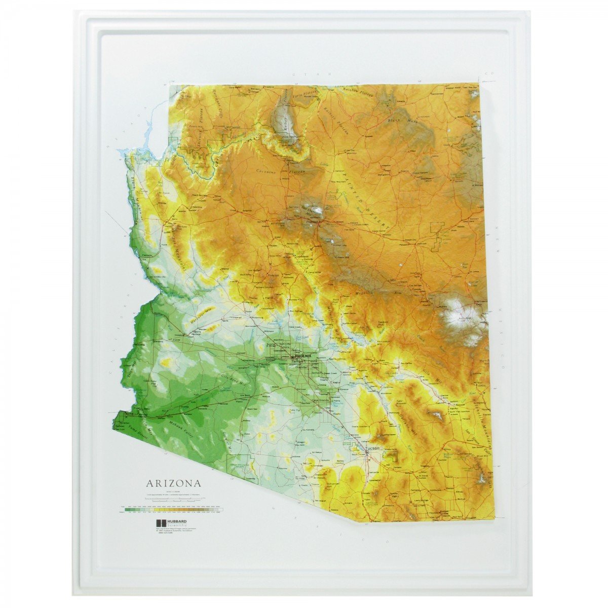
Hubbard Scientific Raised Relief Map 961 Arizona State Map
Relief Map of the Holy Land: Then and Now Wall Chart
Muir Way - California 1977 Shaded Relief Map - Flat 2D Paper Print - Shaded 3D Illusion - Gallery Quality Fine Art Paper & Inks - 100% Cotton & Acid-Free - Made in USA - 24” x 26” 2D Print - No Frame
Muir Way - England & Scotland 1957 Shaded Relief Map - Flat 2D Paper Print - Shaded 3D Illusion - Gallery Quality Fine Art Paper & Inks - 100% Cotton & Acid-Free - Made in USA - 30” x 24” - No Frame
National Geographic New York Wall Map (40.5 x 30.25 in) (National Geographic Reference Map)
Rand McNally Signature Edition World Wall Map: Fol
Hubbard Scientific 3D Hawaii Map | A True Raised Relief Map - You Can Feel the Terrain | Vacuum-formed Molded Map | 36" x 24" | Detailed Topography
Muir Way - South America 1950 Shaded Relief Map - Flat 2D Paper Print - Shaded 3D Illusion - Gallery Quality Fine Art Paper & Inks - 100% Cotton & Acid-Free - Made in USA -24” x 32” 2D Print -No Frame
Muir Way - Iceland 1901 Shaded Relief Map - Flat 2D Paper Print - Shaded 3D Illusion - Gallery Quality Fine Art Paper & Inks - 100% Cotton & Acid-Free - Made in USA - 24” x 18” 2D Print - No Frame
Relief Map of the Middle East: Then and Now Wall C
MOVA Globe Blue Relief Map 4.5"
Muir Way - Utah 1937 Shaded Relief Map - Flat 2D Paper Print - Shaded 3D Illusion - Gallery Quality Fine Art Paper & Inks - 100% Cotton & Acid-Free - Made in USA - 24” x 30” 2D Print - No Frame
National Geographic: United States Physical Wall Map (38.25 x 25.25 inches) (National Geographic Reference Map)
Hubbard Scientific 3D Glacier National Park 416 Map | A True Raised Relief Map - You Can Feel the Terrain | Vacuum-formed Molded Map | 18.5” x 24.5” | Detailed Topography
Restoration Cartographic Greece Minimalist Relief Map, Topographic Wall Art for the Home or Office, Minimalist Series, 12 x 18 Inches
World Decorator, Laminated: Wall Maps World
Relief Map Earth, Snapspheres Magnetic 7.3" Globe, with Geology Map Interior, with Stand
Smithsonian Journeys 30x48 World Wall Map - Blue Ocean Edition (30x48 Laminated) Unknown Binding
Swiftmaps Europe Wall Map GeoPolitical Edition SM EUR SM L
Map of China & Relief Topographical Map of China(Chinese Version) 1:11 400 000 Laminated Double-Sided Waterproof 57x43cm
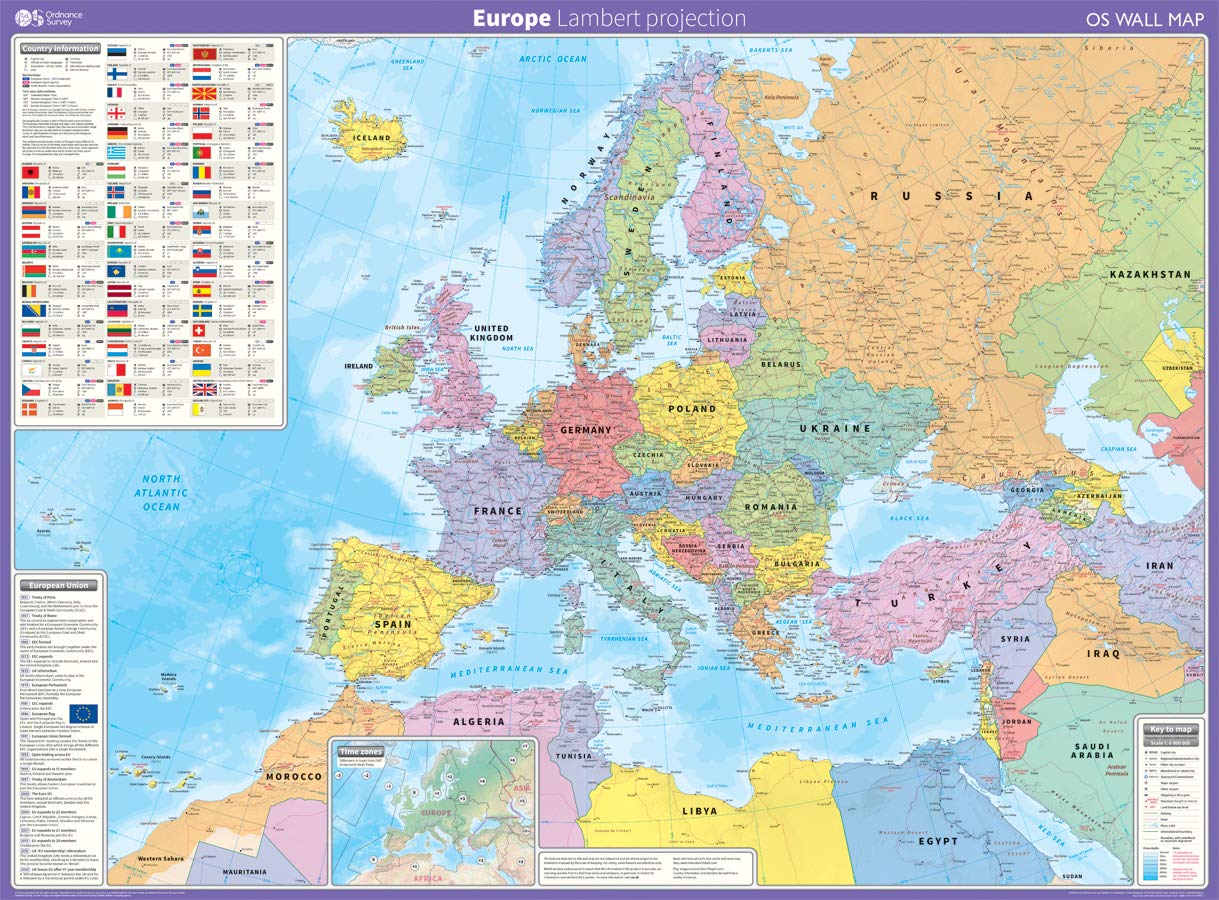
Europe: Lambert projection Map – 12 March 2020
Atlas & Green Scratch Off World Map Large 70x42cm | Ultra Detailed World Map Poster - All US States. Scratch Map World Accessories Kit Gift Tube. Travel Journal Wall Art - Deluxe Cartographic Map
World Executive, Poster Size, Tubed: Wall Maps World
National Geographic: Africa Classic Political Wall Map - Extra Large - 35.75 x 46.25 inches - Art Quality Print
Construction of Maps in Relief. Illustrated
World Physical Sea Relief Map 1:35,000,000
National Geographic Maps Australia Classic, Tubed: Wall Continents
TECNODIDATTICA World Map Atmosphere Relief Rilievo
Exerz32Cm Relief Illuminated Ar Globe With Cable Free Led Light- Physical/Political Dual Map- Augmented Reality App Ios Android - Light Up Globe
Restoration Cartographic Mexico Minimalist Relief Map, Topographic Wall Art for the Home or Office, Minimalist Series, 20 x 30 Inches
South of Kings Gall Orthographic World Map | Most Accurate World Map - Countries are Shown in Correct Proportion to Each Other | Laminated World Map | 36” x 24”
Topanga State Park Trail Map: Topanga, Will Rogers, Tuna Canyon, Backbone Trail, Red Rock Canyon, Temescal Gateway: Shaded-Relief Topo Map (Tom Harrison Maps)
HUBBARD SCIENTIFICHUBBARD SCIENTIFIC AMERICAN EDUCATIONAL PROD 432 - United States Relief Map - United States Relief Map - Each
Stainless Steel Acupressure Massage Stick with Reflexology Map Socks and and Gloves Tool Set – Manual Trigger Point Therapy for Foot Pain Relief, Deep Tissue Meridian Massage, Men Size, Green
Insight GuidesInsight Guides Travel Map Switzerland
National Geographic World Physical Wall Map (45.75 X 30.5 In) Map – 1 January 2018
England South West relief wall map A4 gift box
Altitudes in the Dominion of Canada With a Relief Map of North America
Canada Classic, Tubed: Wall Maps Countries & Regions
Charlesbridge Publishing Sir Cumference and the Viking's Map
Swiftmaps SM WOR PREM EL SM LAM World Premier Wall Map Poster Mural 24h x 36w Laminated


![World Map [Folded]](https://m.media-amazon.com/images/I/81ef0jrm6oL.jpg)